Ivan Potter
Friday, June 10, 2011 1:49 pm
|
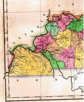
To meet its goal of being the primary historical and genealogical research office for the Jackson Purchase, the Hickman County Historical and Genealogical Society acquired the use of a very rare Hickman County map dating to 1822.
Historical Society Chair LaDonna Lathem expressed her happiness with the importance of this map. “This one document proves once and for all that Hickman County was the mother of all the counties in the Jackson Purchase.”
After the treaty of 1818 between Andrew Jackson and the Chickasaw Nation, this area became the westernmost part of the new American nation. Many veterans of the war of 1812 traveled to the Jackson Purchase for land grants. Hickman County in 1822 comprised all of the land that we now call the Jackson Purchase.
The Historical Society will have maps of the Jackson Purchase on display in their window at the corner of E. Clay and Jackson Street in Clinton throughout the summer. The copy of the 1822 map will be part of this display. Also included will be an 1822 map of Columbus Kentucky as redrawn by Ivan Potter in 1968. This map is a detailed plat land use map of Columbus. The only other copy is the Hickman County Clerk’s Office in Deed Book One.
Many Civil War maps around the Battle of Columbus – Belmont will also be on display.