Last week the Washington Post released a 2 year research study into the new Top Secret America. In the report, the Post found that since 9/11/01, over 850,000 new top security jobs have been created in America by over 1,800 national, state, and local Top Secret Security agencies.
By the data listed on the Washington Post web site map, there are 6 top secret agencies in Frankfort, Kentucky and 8 top secret firms in Lexington, Kentucky.
In this mix of traditional and super modern intelligence organizations, the poster child of both worlds is the National Geospatial Intelligence Agency. When I left Murray State Uni versity in 1969, the Department of Geography was seeking funding for a new research platform called remote sensing. This effort became the Mid America Remote Sensing Center at MSU. In 2010, the agency is still there with its 4th director.
As remote sensing was becoming a new discipline within the art and science of geography during the 1970’s through 1990’s, the function of mapping and territorial intelligence was also being changed.
In military intelligence and mapping, the use of field data and satellite data is redrawing the lines of imagery and mapping. Out of a combination of the old-drawing maps by hand and new-using satellites to draw them came the National Imagery and Mapping Agency.
Now, in 2010, this agency has blossomed into the National Geospatial Intelligence Agency. Same mission, except on steroids. Mapping of real time intelligence is now a critical part of any field command, strategic decision in the White House, or large corporation.
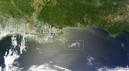
The NGA and its tools were some of the first elements of the federal response teams to go into the Gulf to try and decipher what was happening in real time with the oil spill.
NGA Supports Oil Spill Remediation Efforts
The National Geospatial-Intelligence Agency has embedded personnel with the Unified Area Command, the Incident Command Posts and the Air Coordination Center providing geospatial intelligence support to the Deepwater Horizon Response Effort. NGA has also deployed its Domestic Mobile Integrated Geospatial-Intelligence System on site with the UAC. DMIGS gives NGA analysts the capability to travel to a location in order to directly provide geospatial intelligence analysis and products from any location.
In addition to the regionally deployed work force, NGA analysts located in Saint Louis, Mo., the Washington, D.C. area and other locations around the nation are providing ongoing support to this crisis. NGA's international partners are also part of this virtual work force providing timely, accurate and relevant GEOINT.
NGA has leveraged the full spectrum of remote sensing systems. These systems support the UAC with the ability to account for the location and status of deployed boom, the location of actionable near/offshore oil, and determining the overall oil extent. The information derived from these sensors is getting into the hands of response personnel across the Gulf Region.
Directly in response to this crisis, NGA has transitioned the satellite mission planning, direct downlink, processing, analysis and dissemination capabilities of the University of Miami's Center for Southeastern Tropical Remote Sensing from a pilot project to a fully operational capability. By utilizing CSTARS, NGA has access to a wide range of international commercial satellite capabilities 24 hours a day.
In addition to the above, NGA products include graphics of major infrastructure, environmentally sensitive regions along the Gulf coast, operational planning map atlases and notices for maritime and air navigation safety. NGA products and services ensure the U.S. Coast Guard leverages every available resource as part of the Deepwater Horizon Response Effort.”


